
Even giant, meat-eating dinosaurs needed a drink of water now and then. Footprints found on the Isle of Skye, off Scotland’s northwest coast, show that large predatory dinosaurs and plant-eating giants were both wading through the same shallow freshwater lagoon roughly 167 million years ago, at what may have amounted to a prehistoric watering hole.
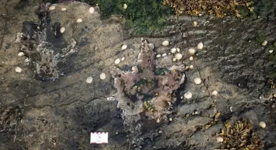 Why these footprints matter: unlocking dinosaur secrets from the Isle of Skye. Image: Paige E. de Polo
A Rare Window Into the Middle Jurassic
The discovery comes from the Kilmaluag Formation at Prince Charles’s Point, on Skye’s Trotternish Peninsula, where researchers from the University of Edinburgh documented 131 dinosaur footprints in a single tidal platform. That makes it one of the largest dinosaur tracksites ever found in Scotland. The tracks date to the Late Bathonian, part of the Middle Jurassic period around 167 million years ago, an era notoriously underrepresented in the global fossil record. Because so few Middle Jurassic dinosaur bones have ever been found anywhere, scientists rely heavily on footprints like these to reconstruct how major dinosaur groups were evolving and behaving at the time.
The tracks fall into two broad categories. Large, flat, circular impressions belong to sauropods, the long-necked plant-eaters, most likely non-neosauropods or early-branching members of that group rather than a specific giant like Brachiosaurus. The second set, sharper and three-toed, belongs to megalosaurids: large, ground-shaking carnivores that were distant, older relatives of animals like T. rex. Finding megalosaur tracks in this kind of preservation is genuinely rare, and having them alongside sauropod tracks in the same layer is rarer still.
Solving a 40-Year-Old Misidentification
Some of the large circular depressions at this site were first documented back in the early 1980s by geologist Julian Andrews, who interpreted them as fish resting burrows, trace marks left by fish settling into soft sediment. The new study re-examined those same structures and found sequential manus and pes impressions, front and hind foot prints in the pattern a walking sauropod would leave, that don’t match how fish traces form. That reinterpretation opens an unusual possibility: some “fish burrows” catalogued at other sites around the world might actually be unrecognized dinosaur tracks.
What the Footprints Reveal About Behavior
Of the 131 tracks catalogued, 65 were identified as theropod (meat-eater), 58 as sauropod (plant-eater), and 8 couldn’t be confidently assigned to either group. By analyzing the direction and spacing of each trackway, the research team, led by Tone Blakesley of the University of Edinburgh, concluded that both groups of dinosaurs were moving along the edge of a shallow lagoon rather than passing through in a straight line.
To capture the site in enough detail to draw those conclusions, the team flew drones over the tracksite and collected more than 4,500 images, which were processed using photogrammetry to build precise 3D models of individual footprints and full trackways. That level of detail revealed subtle shifts in direction the team describes as “milling behavior,” consistent with animals moving back and forth along a lagoon margin rather than traveling with any single destination in mind.
Fun Fact
Prince Charles’s Point stands out from every other dinosaur tracksite documented on Skye for one reason: it has far more theropod tracks than sauropod tracks. Researchers think that’s because this lagoon held freshwater specifically, while other Skye sites, like Rubha nam Bràithrean and Cairidh Ghlumaig, formed in saltier or brackish conditions that sauropods may have preferred.
“The footprints at Prince Charles’s Point provide a fascinating insight into the behaviours and environmental distributions of meat-eating theropods and plant-eating, long-necked sauropods during an important time in their evolution,” said Tone Blakesley, who led the research as part of his Master’s degree at the University of Edinburgh’s School of GeoSciences. “On Skye, these dinosaurs clearly preferred shallowly submerged lagoonal environments over subaerially exposed mudflats.”
Where History and Prehistory Overlap
Prince Charles’s Point carries a second, much more recent layer of history. In 1746, the same stretch of coastline sheltered Charles Edward Stuart, better known as Bonnie Prince Charlie, and Flora MacDonald while they hid from British soldiers following the Jacobite defeat at the Battle of Culloden.
“Prince Charles’s Point is a place where Scottish history and prehistory blend together,” said Steve Brusatte, Personal Chair of Palaeontology and Evolution at the University of Edinburgh and a co-author on the study. “It’s astounding to think that when Bonnie Prince Charlie was running for his life, he might have been sprinting in the footsteps of dinosaurs.”
IFLScience — 167-Million-Year-Old Dinosaur Footprints Suggest Megalosaurs and Sauropods Drank Together at Freshwater Lagoon
University of Edinburgh — School of GeoSciences Press Release
How many dinosaur footprints were found on the Isle of Skye
Researchers documented 131 in-situ dinosaur footprints at Prince Charles’s Point on Skye’s Trotternish Peninsula, making it one of Scotland’s largest dinosaur tracksites. Of these, 65 belonged to theropods, 58 to sauropods, and 8 couldn’t be identified.
What kinds of dinosaurs left these footprints
The tracks belong to two groups: large megalosaurid theropods, carnivorous relatives of dinosaurs like T. rex, and sauropods, long-necked herbivores classified as non-neosauropods or early neosauropods rather than a specific genus like Brachiosaurus.
Why were some tracks previously mistaken for fish burrows
In the early 1980s, geologist Julian Andrews interpreted large circular depressions at the site as fish resting burrows. The new study identified sequential front and hind foot impressions within those same structures, showing they were actually sauropod tracks.
How did researchers study the footprints in such detail
The team used drones to capture over 4,500 photographs of the tracksite, then applied photogrammetry to build precise 3D models of individual tracks and full trackways, revealing subtle directional patterns described as milling behavior along the lagoon edge.